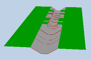
Export profiles of all sections with X, Y, Z format.
This feature allows you to export in a text file with$separators for section information and tab separators for numeric values all the profiles of the sections of the minor/medium bed and/or of the major bed that are entered as width-elevation, abscissa-elevation, circular, curvert, power, rectangular, or trapezoidal format.
Comments (written after the special character% in the first column) can also be written.
To run the export, you must be in geometry mode and choose “Export profiles of all sections with X, Y, Z format”. The software then offers:
- to choose between sections of minor/medium or major bed,
- choose the file format: -* linear text (longitudinal abscissa, Section) -* 3D text (x, y, z, idminmoy) -* 3D kml format (not yet managed, but in progress …) -* 3D cvs format HEC-RAS style: river, reach, station, x, y, z (not yet managed, but in progress …)
- choose the format of the sections (original or systematically converted to abscissa-dimension)
- choose to add comments at the head of the file (type of bed) as well as between each section (after the character%, its longitudinal abscissa, its type of format)
- choose to add comments on the nodes separating the reaches comprising the sections (after the % character, the graphic coordinates and geolocation of the midpoint, the names of the upstream and downstream nodes, as well as their graphic position and their geolocation)
- choose to write the geolocation (latitude, longitude in degrees and its decimal fractions, or in metric values depending on the chosen option)
- choose to have a 3D visualization of the exported geometry
Then a file name can be chosen for this export, with txt extension.
- In “linear text” format, the generated file is in the same format as the one allowing the import of section data into a reach. It contains a line describing the section, with fields separated by the code$, then lines describing the numeric parameters of the section. It can contain optional comments starting with the character % in the first line.
The descriptive line of the section contains its general information, separated by the character$ (see for details).
The following lines (2 or more depending on the format) contain the geometric parameters of the section, according to its format (see for details).
- In “3D text (x, y, z, idminmoy)” format, the file can contain optional comment lines as above, then the points x, y, z, idminmoy in four columns separated by tabs:
- Column 1: longitudinal abscissa of the section (x)
- Column 2: coordinate of the current point in the profile section (y)
- Column 3: elevation of the current point (z)
- Column 4: flag idminmoy (0 or 1), with a value of 1 if this (these) point(s) is the delimitation point of the minor-mdium beds, and 0 otherwise. For the moment, if the minor-medium overflow elevation does not correspond to a point indicated, this flag will therefore not be entered. In the future we will then create an additional point for this particular point. Note that in the linear format preceding this is well managed because the minor-medium elevation is indicated in a specific line before the description of the points constituting the section.
This file (in its form with comments) can be imported into a 3D visualization tool linked to below.
If the 3D visualization option is selected (see above), we will also have a direct visualization in an interface window. But for the moment this visualization is limited in terms of functionality and maximum points that can be managed (limitation related to the possibilities offered to date by Windev 25, but which should evolve in the future: modifiable angle of view, transparency, etc.) . Other functions make it possible to make 3D visualizations in a Matlab script provided as an example under ex45_3Dvisu under sic / dat, from the 2 file formats treated above. If the comment option has been chosen, then the original format of the section is indicated in this comment, in addition to the longitudinal abscissa of the section.
Soon the 2D positions x,y will be based on the geolocalisation of the nodes and sections (in option), and not only on a linear longitudinal reference as now.
In “kml 3D” format the coordinates of the points of the sections will be in geolocation (latitude, longitude) and altitude, and in kml format that can be imported into Google Earth (soon … in progress).
In “3D cvs” format, the coordinates of the points of the sections will be written in the csv import format in HEC-RAS style, with 6 columns: river, reach, station, x, y, z. As we have this information in SIC we will also add 2 additional columns with the name of the section as well as the longitudinal abscissa (not yet managed, but in progress …).
The files generated in these 2 formats can either contain the information in the original mode of the section (configured as rectangular, box culvert, trapezoidal, etc., width-dimension, abscissa-dimension), or transformed into abscissa-dimension.
Example in “3D text (x, y, z, idminmoy)” format:
%
% DEM of the Minor-Medium bed
%
%
%   0   Abscissa/Elevation
0   -3.18   48.08     0
0   -3.18   44.3     0
0   0   44.3     0
0   3.18    44.27     0
0   3.18    49.05     0
%
%   100 Abscissa/Elevation
100 -8.3    48.85     0
100 -5.4    46.57     0
100 -4.85   46.57     0
100 -3.2    45.01     0
100 0   45     0
100 3.2 45.02     0
100 4.7 46.72     0
100 6.85    48.75     0
%
%   200 Abscissa/Elevation
200 -7.1    49.18     0
200 -4.4    46.56     1
200 -3.3    45.09     0
200 0   45.13     0
200 3.6 45.16     0
200 5.15    46.62     0
200 7.65    48.96     0
%
%   300 Abscissa/Elevation
300 -7.75   49.34     0
300 -4.86   46.58     0
300 -3.25   45.04     0
300 0   45.04     0
300 3   45.09     0
300 4.55    46.67     0
300 7.5 49.33     0
%
%   400 Abscissa/Elevation
400 -6.7    49.58     0
400 -3.75   47.44     0
400 -2.7    45.29     0
400 0   45.23     0
400 3.3 45.46     0
400 5   47.7     0
400 6.8 49.87     0
%
%   500 Abscissa/Elevation
500 -4.95   48     0
500 -2.3    45.45     0
500 0   45.21     0
500 2.35    45.42     0
500 4.4 47.92     0
%
%   550 Width/Elevation
550 0   45.28     0
550 -1.96   45.52     0
550 1.96    45.52     0
550 -3.03   45.84     0
550 3.03    45.84     0
550 -4.665  48.07     0
550 4.665   48.07     0
550 -4.885  49.31     0
550 4.885   49.31     0
The export inserts a line break between each new section.
All sections are managed regardless of their format (abscissa-dimension, width-dimension and parameterized), as well as model sections. The homothety in y is also managed for width-dimension and parameterized formats, but not yet for abscissa-dimension, nor the homothety in z (soon …).
A 3D visualization tool of the geometry is available with your internet browser at the following address: http://sic.g-eau.fr/sic_tools/geometrie.html, or with a Matlab script provided as an example under ex45_3Dvisu under sic/dat.